The TLALOCNet GSAC data center
For all GPS site and data queries click here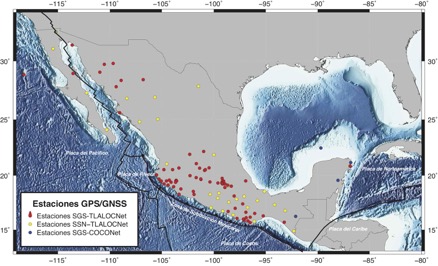
TLALOCNet is a combined atmospheric and tectonic cGPS-Met network in Mexico for the interrogation of climate, atmospheric processes, the earthquake cycle, and tectonic processes of Mexico. TLALOCNet spans most of Mexico and links existing GPS infrastructure in the rest of North America and the Caribbean to create a continuous, federated network of networks, the Network of the Americas, spanning from Alaska to South America. This GPS network is operated by the Servicio de Geodesia Satelital at the Instituto de Geofisica, UNAM and has been funded by NSF, CONACyT, and UNAM-PAPIIT.
Data from this archive should be acknowledged following these guidelines: Acknowledgements / Agradecimientos
For additional information on this project please visit the TLALOCNet website at SGS-TLALOCNet
![]()